************************************************************************************************************************************************
START MAIN CONTENT HERE.
************************************************************************************************************************************************
MODIS Viewer
MODIS Viewer

|
Welcome to the MODIS Browser at NASA Langley
|
This website provides near real-time as well as historical MODIS
multi-spectral imagery over the Continental US. The archive dates
back to Dec 2, 2002. Use the pull down menus above to select
and search a MODIS image.
|

|
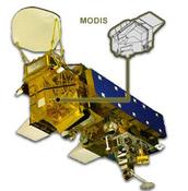
The MODIS
(Moderate Resolution Imaging Spectroradiometer) instrument flies
on board the NASA
TERRA and
AQUA
spacecraft. The TERRA and AQUA satellites were
launched in Dec 18, 1999 and May 4, 2002 respectively.
The sun synchronous polar orbiters (98° inclination) have an
equatorial crossing time at 10:30am (TERRA) and 1:30pm (AQUA)
local time.
|
|
The TERRA and AQUA MODIS direct broadcast data is received thru
SSEC (U.WISC) X-Band Antenna. All MODIS imagery on this
website are generated at NASA Langley using the
McIDAS
(Man computer Interactive Data Access System) software.
|
 You can use the product viewer to examine our Composite North Pole Modis domain
**** END MAIN CONTENT HERE. ****


 You can use the product viewer to examine our Composite North Pole Modis domain
